Quarry landscapes are often composed of multiple layers of activities from more or less continuous activities through long time. Unlike settlements, the different time layers do not form well stratified layers, but rather a complex system of use, re-use and frequent re-location of material culture. Individual quarry sites were commonly re-visited during several periods, spoil material was moved to make space for new quarrying, and roads/other infrastructure were more or less continuously moved. In addition, many quarry landscapes, particularly those which did not have permanent settlements of work force, tend to have little datable material culture. However, finding the time depth of a quarry landscape is one of the most crucial research questions when it comes to evaluating its significance. Naturally, the earliest phases of quarrying are less visible (and more difficult to identify) than the younger, but not less significant.
Given such limitations, finding time depth in quarries can be achieved by several methods:
Through direct dating: charcoal and other organic remains can be found in settlement areas and trapped in spoil heaps.
Through indirect dating: ceramics, inscriptions and other epigraphic data
Through consumption: one of the most valuable methods of dating quarrying activities is through consumption of the rocks, being buildings in a city or other well-dated objects.
Through technology: the interpretation of tool marks may reveal the use of specific tools and tool materials (stone, iron) that can be dated
Through relative dating of events: such as overlapping layers of quarrying activities
Drawing together and characterising the micro-level data, as categorised above, allows us to build a composite picture of the ancient quarrying process and its social context. Multi-disciplinary perspectives are clearly key in this analytical phase, given that the objective is to define and characterise all the empirical data in terms of how it constitutes the material resources that make up a quarry landscape. This phase of expert analysis needs to describe and characterise the empirical data in terms of what insights can be made into how quarrying was undertaken in the past. Given that empirical data is always fragmentary comparative analysis with other ancient quarry sites, along with indirect evidence, is also key to interpretation of the micro-level.
Interpreting the technology used to extract a resource may often be built from analysing a range of data sets, often indirectly associated, particularly when the tools used in the quarrying process are absent. Tool marks on quarry faces, partially worked objects, the constituents of spoil heaps and comparative analysis, can be effective ways to interpret the production process (example sheet 2).
An analysis of micro-level data that informs about the logistics of how stone was transported from a quarry is key to visualising and delineating the boundaries of an ancient quarry landscape. In some instances purpose-built roads were necessary to even out the topography, yet in others, a transport route may only be indicated by cairns and sightlines. Analysing the presence/absence of such transport infrastructure is important in assessing environment, longevity of the production process and often the role of the state in such operations (example sheet 3).
In terms of making inferences into the social context of ancient quarrying, there are key questions that we need to ask of this data. For instance, the size of labour forces, did they reside permanently at the quarry, levels of social organisation and the extent to which such activities may have been controlled by the ‘state’ or other type of centralised bureaucracy.
An example on how to apply such methodology in analysing a quarry site is given in example sheet 4.
Ideally, a “quarry” may be described as a unit of stone production, continuously exploited for a specific purpose in a specific period. Naturally, far from all quarries are ideal, some exhibit one or more hiatuses in the production, and some contain several layers of exploitation for different purposes. A quarry unit may be the result of one day’s work or tens of years. Individual quarries may start separate and later grow together into one large unit, in which the individual components remain invisible for us.
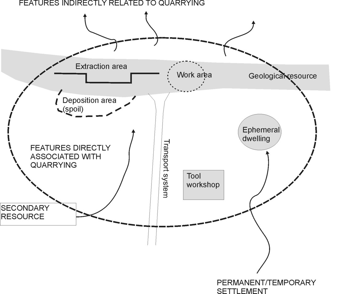
A quarry unit features (ideally) a stone resource (or part of such), remains from the various steps of production (quarry face, spoil heaps, work areas, unfinished products, tools, etc.), logistic features and remains of the social life around the quarrying (ceramics, shelters, etc.)(Figure 4)(example sheet 5). There may or may not be evidence of exploitation of secondary resources. There is an input of people and resources for sustaining the production, and an output of more or less finished stone products. To a smaller or larger extent, the unit is a part of a larger organisation and social context.
Figure 4. Ideal representation of a quarry unit (click to enlarge).
In most cases, quarry landscapes are multilayered and multifunctional. Thus, following the definition of elements related to quarrying and the micro-level analyses of them, such layers/functions need to be identified as groups or systems of quarries. The term quarry complex can be defined as “a collection of quarry elements related to each other in time, space and/or function”. The identification of quarry complexes is an aid in visualising similarities and differences in a quarry landscape, acknowledging that there may be different ways of articulating significance for different quarry complexes. A simple way of viewing a quarry landscape is thus as a collection of quarry complexes.
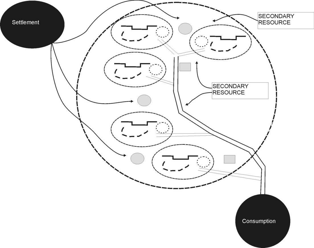
In a general view, a quarry complex may be visualised as a system of interconnected quarries sharing social infrastructure and logistics, input of labour force and secondary resources and output of products (figure 5).
The criteria on which a complex is defined depend on many factors, and may be one or combinations of the following:
• Time/period (“Historical Complex”)
• Resource (rock/commodity)
• Production (technology)
• Function/consumption (products)
A division by time/period requires control and knowledge of the chronology, which may have been achieved directly by exact dating techniques or indirectly through i.e. consumption patterns. An indirect way of approaching chronology may be by defining complexes from production technology. In several cases, quarrying activities have been going on for thousands of years, illustrating unbroken human interaction with a specific resource through changing historical periods. Thus, it may be of particular interest to visualise such longevity of exploitation, and not split it up in chronological layers (example sheet 6).
Figure 5. Simple model for visualising a quarry complex limited by the resource, as a number of connected quarries sharing common features of social infrastructure and logistics. (click to enlarge).
As quarry landscapes differ significantly in complexity, size and character, it is difficult to recommend a standard method of documentation and mapping of them. But given that such sites rarely are subject to highly detailed archaeological investigations, it is possible to suggest a procedure that can provide an overview of the features in a quarry landscape and their connections in time and space with relatively small efforts.
As particular archaeological landscapes, quarry landscapes often share the following characteristics, which are important to take into account before surveying:
Quarry landscapes often display exploitation activities over long periods of time, perhaps thousands of years, and thus show significant evolution of technology and organisation of the quarrying through their lifetime
Modern stone quarrying is often situated in the same deposits as the ancient one. In essence, stone resources that were attractive two thousand years ago will still be commercially interesting today. Thus, there are often special challenges in creating a balance between ancient and modern quarrying
Quarry landscapes often cover large areas
Quarry landscapes are closely connected to geological formations (stone resources) and their spatial distributions follow the bedrock geology
Pre-survey studies:
Geological maps and other geological information from the area are important for predicting the spatial extent of quarry landscapes and for knowing the stone resources in question
Satellite images and/or aerial photographs may be extremely useful for locating quarries and logistical features
A pre-study of the consumption of the stone(s) in question is valuable for better recognition of products and production patterns in the field
When planning a survey, the level of accuracy has to be balanced with available time and funding. As many documented quarry landscapes cover an area of 100 square kilometres or more, it is obvious that a highly detailed survey with accuracy (or level of details to be documented) less than one metre will be extremely time consuming. For a general survey, it is recommended to work on 5-10 metres accuracy/detail level. This gives a good balance between speed, necessary accuracy and costs. Within that framework, it is possible to work with low-cost GPS equipment combined with the standard level of accuracy given on satellite images.
Surveying:
A survey should include geological mapping and resource characterisation, since the exploited resources define the limit of potential, previously undiscovered quarry areas.
It is convenient to divide recordings/observations into main classes (ex. quarry, road, man-made feature, etc.) which are further divided in subclasses.
A pre-defined table structure/shapefile for GPS-based data-collection should contain enough fields to allow for spatial analyses of several datasets, to facilitate post-survey interpretation of inter-dependent features. Separate tables should be used for point registration (i.e. artefacts), polygon registration (i.e. quarry) and line registration (i.e. road). An example of shapefiles for GPS field surveying is given in example sheet 7.
A survey should include the recording of the physical condition of the features (destruction, erosion/weathering) and an evaluation of immediate threats from modern activities.
An inventory of quarry sites/landscapes within a region or nation is of great value for being able to view and manage this kind of heritage in a holistic way. A national survey will provide an overview of the number of sites/landscapes, their legal status, their condition for conservation and the distribution of typologies. Since quarry landscapes in a global context are poorly documented and rarely protected as cultural heritage, such an inventory is invaluable for shaping a national policy of conservation and being able to compare and evaluate the overall importance of the sites. A database designed to meet such demands should contain:
Rock types (main groups and classifications)
Main commodities (i.e. millstone or building-stone)
Age (period(s) of quarrying)
Legal status (registered or non-registered, protected, etc.)
Protection (inside or outside protected area, ex. nature reserve)
Condition (preservation, destruction)
Main threats (i.e. urban development, etc.)
Reference to research and other work at the site
Within the framework of QuarryScapes, a national inventory of quarry sites was completed in Egypt. Structure of the database and examples of data entries and use of the database is presented in Example sheet 8.
Untitled Document
NEWS
December 2009 New book: a special volume with papers from the QuarryScapes project soon printed.
November 2008 Final workshop: the third QuarryScapes workshop was held in Aswan 12. - 15. October
March 2007 QuarryScapes fieldwork in Egypt: The final season of survey at the Aswan silicified sandstone quarries revealed previously undocumented ancient paved roads
December 2006 Second Aswan field season The second QuarryScapes fieldwork season in Aswan took place through November 2006.
November 2006 First symposium
The first QuarryScapes symposium took place at Divan Talya hotel in Antalya (Turkey) 15-17 October 2006.